Category Archives: Family

Cecil Ernest Sampson Byrnes in Changi POW camp

My grandfather’s fate after the fall of Singapore had always been unclear. Recently I found out that the University of Melbourne Archive (UMA) had digitized their collection of Australian Red Cross (ARC) POW World War II enquiry cards. These cards were used to record requests for information, usually by family members in Australia, as to the whereabouts of prisoners of war.

It can be tricky to find the best place to search the card collection. The cards are owned by UMA. After digitization the collection became searchable via the Library repository. To get some background:

Here is a link to the record describing Cecil’s card, and here is a pdf of Cecil’s ‘Missing, Wounded and Prisoner of War Enquiry Card‘. For convenience I’ve copied a section of it below.

Copyright: University of Melbourne Archive

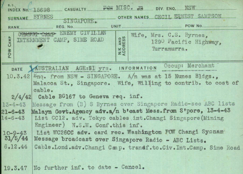
The information on the cards is very condensed so the UMA provides a list of the most common abbreviations.

From the card we can see that Cecil was a civilian, the enquiry came via the NSW branch of the ARC, and that he was initially in the Changi Camp before being transferred to the Enemy Civilian Internment Camp at Sime Road. The ‘next of kin box’ shows Lily’s contact address as 1290 Pacific Highway, Turramurra. Cecil is said to have been 51 years old, although I believe he was 49 at the time. His occupation is ‘merchant’ which is suitably vague. During the 1930s he was managing a tin mine at Panang but he was a certified accountant and had been involved in various commercial activities.

10-3-1942 Cecil’s address is given as 15 Nunes Building, Malacca Street, Singapore. These photos from 1982 show the Nunes Building past its prime but in its day it was in an important commercial hub. To gain an impression of what the area was like during the 1950s I can recommend Naffi’s Reminisces of Dad, 1952-1960. This card entry mentions that Lily is willing to contribute to the cost of the cable. I wonder how much it was.

2-4-1942 a cable is sent to Geneva requesting information.

13-4-1943 and 21-6-1943 a year passes. I don’t know what these entries mean. ‘Message from (B) S Byrnes over Singapore Radio – see ABC lists’. More research needed.

14-6-1943 List CC12 advises Tokyo cables: interned in Changi. The mention of ‘mining engineer’ is plausible. In 1931 Cecil became a member of American Institute of Mining and Metallurgical Engineers. Looks like NSW ARC checked this detail with Lily as initially his occupation was given as ‘merchant’.

10-9-1943 List WC26CC advises card received Washington POW Changi Syonan (Japanese for Singapore). This seems to confirm that Cecil is in Changi POW Camp.

31-5-1944 another radio broadcast

6-12-1944 a cable advises that Cecil had been transferred from Changi to the Civilian Internment Camp at Sime Road.

19-3-1947 no further information available so the case is closed.

In the meantime the war in the Pacific had ended in August 1945 so presumably Cecil was released soon after then. Cecil appears to have been incarcerated for a total of 3 1/2 years, from the fall of Singapore in February 1942 until its liberation in September 1945.

Here is an interesting blog post describing the Sime Road camp.

And here is a listing for Cecil on the FEPOW website.

The University of Cambridge Digital Library has a collection entitled ‘Voices of civilian internment: WWII Singapore‘, which includes the ‘Changi and Sime Road civilian internment camps: nominal rolls of internees (RCMS 103/12/22)‘ which lists Cecil. Cecil’s camp register number is listed as 2013, card index number 305, age 49, occupation miner, nationality Australian.

The Geography of our travels around Germany

In 2012 we went on a 10-week family holiday around Europe. We had been thinking about it for a few years and everything came together nicely in the summer of 2012. Barbara’s 30-year high-school reunion was taking place in her hometown in south-western Germany. This gave us some definite dates and places to plan around. We also wanted to see family in other parts of Germany, and friends in Austria and France. Over a few months we worked out a travel plan that used a combination of plane-flights and driving, to criss-cross Europe. At times it felt like we were working on a solution to the travelling salesman problem.

We were very aware that the boys would be missing a number of weeks of school. Understandably their teachers were not happy about this and we needed to make the case that the trip would be educational as well as valuable in the vague, personal sense. So we made a conscious effort to discuss with the boys the history and geography of the places we visited. We tend to discuss things with them anyway so really we were just trying to make the most of a wonderful trip.

A theme that soon became obvious was the river Danube.  Many of the places we were visiting were either on, or close to, the Danube. The Danube flows through many countries but for this trip we would only see it as far downstream as Vienna. In German it is ‘the Donau’, so I’ll use that name from now on. I’ll mention the places we visited, not in chronological order, but according to the river’s flow, starting with its source.

The course of the Danube

The course of the Danube

I suspect the source of any great river is a point of contention. The river-head might be made up of many tiny tributaries so it may not be easy to identify a single source. Hydrologists have rules for determining which tributary is the more major but this might change over time. And speaking of time, it may be that a particular location is regarded as the source for historical reasons. To point out that, say, the Romans regarded a place as the source does carry some historical authority. That is the case with the Donauquelle in the Black Forest town of Donaueschingen. You get an idea of the claim being made by the name of the town. The Donau has two main tributaries: the Brigach and the Breg, but the confluence was originally surrounded by swampy areas.

Donauquelle near Stadtkirche St. Johann Donaueschingen

Donauquelle near Stadtkirche St. Johann Donaueschingen

Information sign at Donauquelle near Stadtkirche St. Johann Donaueschingen.

Information sign at Donauquelle near Stadtkirche St. Johann Donaueschingen.

Here we are at the spring that is supposedly the source. The Roman Emperor Tiberius and various German Emperors came here for a look so maybe it’s true. The spring is now next to (and somewhat below) St John’s church. On the afternoon of our visit the parishioners had held a light lunch to raise funds for church repairs and we were happy to help them eat the left-overs.

Donaueschingen has an elevation of about 680m above sea level. The sign above points out that the mouth of the Donau, at the Black Sea, is some 2840km away. So water really doesn’t need much of a gradient to form a substantial river. (Note: the source of the two tributaries are somewhat higher at about 1000m). The Donau flows generally eastward across southern Germany, through northern Austria, along the border of Slovakia and Hungary, then south through Hungary and Serbia and finally turning east again forming the border between Bulgaria and Romania. It empties into the Black Sea via an extensive delta. The river is often divided into three sections: upper, middle and lower. The upper section ends when the river leaves Austria, so all the places we visited are part of this section.

Rohrach

The Rohrach at Geislingen flows into the Eyb which flows into the Fils which flows into the Neckar at Plochingen, which flows into the Rhine at Mannheim.

Donaueschingen is in the east of the Black Forest. Rain falling on the eastern side of the Black Forest tends to flow into the Donau while rain on the western side ends up in the Rhine (via the Neckar River). However, the hydrology is actually more complex than this suggests. Much of the state of Baden-Württemberg lies on a limestone plateau. The limestone has leached-away forming underground caverns and streams. These underground streams often flow towards the Rhine because it is lower than the Donau. The upshot is that although the Donau appears to have a substantial catchment in this area, in practice much of it does not contribute directly to the Donau. Instead a great deal of the flow is gained from substantial downstream tributaries.

In addition, the source of the Neckar is at Villingen-Schwenningen which is not that far from Donaueschingen! So when traveling around the Black Forest it is hard to know which rain-shower will end up in the Atlantic via the Rhine and which will find itself in the Black Sea via the Donau.

Barbara grew up in Geislingen an der Steige, which is east of the Black Forest. It is not far from Ulm, which in on the Donau. However, Geislingen is on the River Fils, which is a tributary of and flows westward to the Neckar, which, in-turn, flows through Stuttgart and then to the Rhine. Meanwhile at Ulm the Donau flowing northeast.

Geislinger Steige

Train climbing the Geislinger Steige

An explanation is that between Geislingen and Ulm the Swabian Jura rises some hundreds of metres. This low mountain range has provided a barrier to movement and trade between the Neckar and the Donau since before Roman times. The steep climb between Geislingen and Amstetten is called the Geislinger Steige. The B10 road climbs this hill as does a very steep section of the main Stuttgart to Munich railway line.

Whenever in Geislingen we visit the ruins of Burg Helfenstein which overlooks the whole area including the train-line climbing the steige. We have photos taken over decades similar to the one taken on the 2012 trip.


Der Grosser Blau, one of the small streams which flows through Ulm and into the Donau

Der Grosser Blau, one of the small streams which flows through Ulm and into the Donau

Surfing a tributary of the Isar in Munich

Surfing a tributary of the Isar in Munich

The Große Arbersee flows into the Großer Regen, which flows into the Schwarzer Regen, which flows into the Regen which flows into the Donau

The Große Arbersee flows into the Großer Regen, which flows into the Schwarzer Regen, which flows into the Regen which flows into the Donau


The Danube at Passau from the Schanzlbrücke

The Danube at Passau from the Schanzlbrücke


To be continued …